

AUA_ The 6th GIS Congress of the Agricultural University of Athens concludes with a Strong Scientific, Innovative, and International Footprint
6th Congress on Geographic Information Systems and Spatial Analysis in Agriculture and the Environment
The 6th GIS Congress of the Agricultural University of Athens Concludes with a Strong Scientific, Innovative, and International Footprint
A multidimensional three-day conference on precision agriculture, geospatial data, artificial intelligence, and the environment
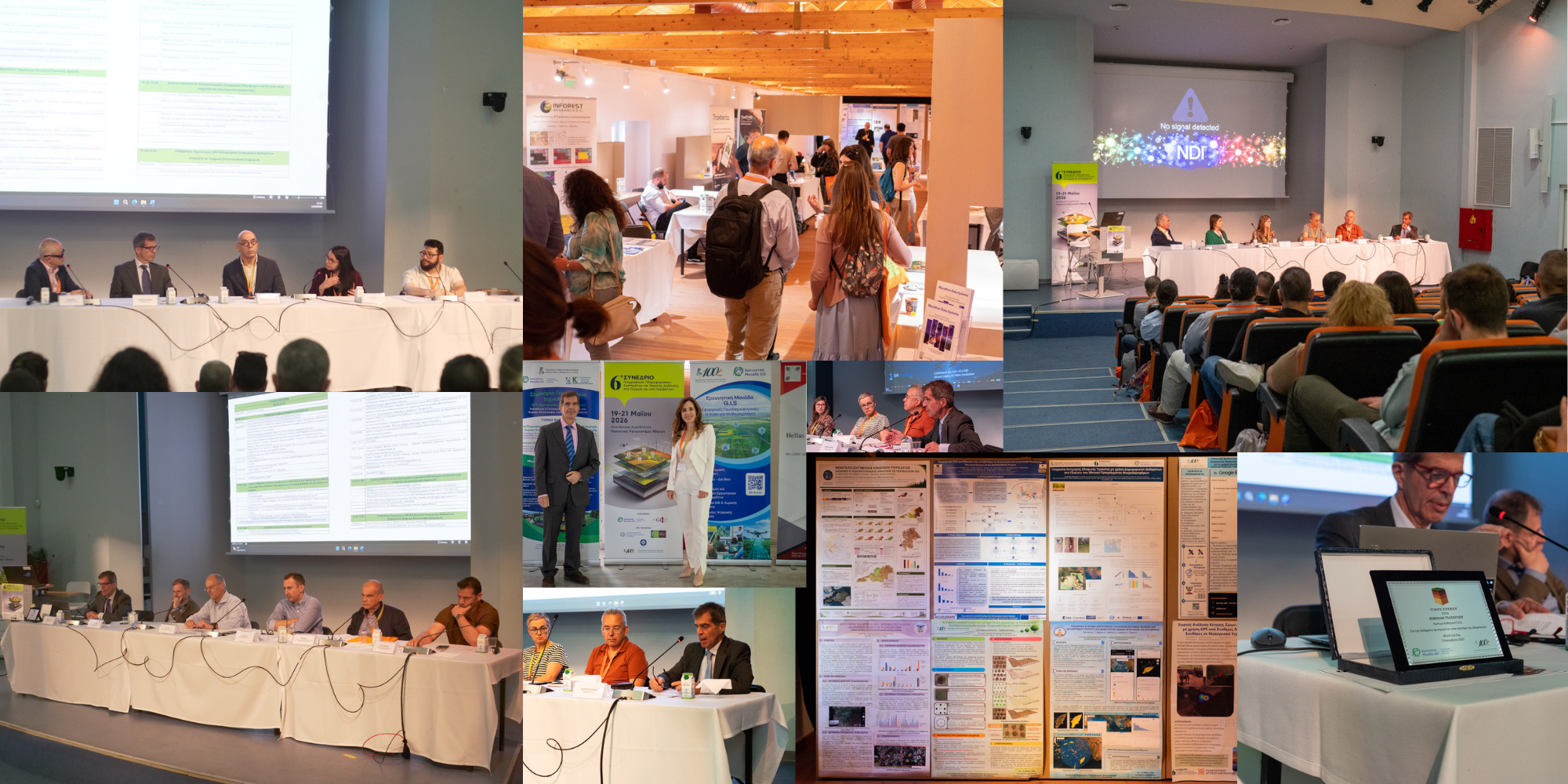
The 6th Congress on Geographic Information Systems (GIS) and Spatial Analysis in Agriculture and the Environment successfully concluded, marking an important milestone in scientific dialogue and technological innovation in the fields of digital agriculture and environmental management. The Congress was held from 19 to 21 May 2026 at the Conference Amphitheatre of the Agricultural University of Athens (AUA), while the 3rd GIS Congress EXPO was hosted simultaneously at the Agricultural Museum of AUA.
The Congress was organized by the GIS Research Unit of the Agricultural University of Athens in collaboration with the Hellenic Association of Geographic Information Systems (Hellas GIS), under the auspices of the Agricultural University of Athens, the Ministry of Rural Development and Food, the Ministry of Environment and Energy, and the Municipality of Athens. Bringing together researchers, academics, professionals, public authorities, and technology providers from Greece and abroad, the Congress evolved into a dynamic forum for science, technology, education, and networking, highlighting the strategic role of geospatial technologies in modern agriculture, natural resource management, and climate change adaptation.
The 6th GIS Congress extended beyond the framework of a conventional scientific conference by combining:
- more than 57 scientific presentations,
- thematic panels and special sessions,
- hands-on workshops,
- a technology exhibition,
- awards for young researchers,
- diploma award ceremonies, and
- networking activities for alumni and professionals.
More than 57 scientific contributions were presented during the three-day event, including 45 oral presentations and 12 posters from universities, research institutions, public organizations, and private companies from Greece and abroad. The scientific topics covered a broad spectrum of applications, including remote sensing, photogrammetry, precision agriculture, artificial intelligence, digital soil mapping, hydrology, biodiversity, natural hazard management, and environmental monitoring.
Particular attention was given to applied research presentations utilizing geospatial data, artificial intelligence, machine learning, drones, and WebGIS technologies under real-world production conditions. Applications included crop monitoring through vegetation indices (e.g., NDVI), precision viticulture technologies, olive cultivation and olive fruit fly management systems, water stress assessment tools, and 3D UAV-based photogrammetric mapping.
Special scientific sessions and panel discussions focused on:
- the National Greek Microsatellites Programme, emphasizing the strategic importance of Earth Observation data for monitoring agriculture, water resources, soils, and the environment, as well as for supporting modern spatial information infrastructures and operational tools for public administration and research;
- the Hellenic GeoSpatial Soil Data Hub and the development of a National Geospatial Soil Information Database, directly connected to precision agriculture, sustainable soil management, protection of agricultural land, and the new European Soil Monitoring framework;
- digital geospatial platforms, drones, WebGIS technologies, and artificial intelligence applications in primary production.
The practical dimension of the Congress was reinforced through seven specialized workshops, offering participants hands-on experience in Geospatial Artificial Intelligence (GeoAI), Google Earth Engine, spatial modelling, geospatial data management with R, UAV photogrammetric processing, WebGIS development, GIS-based land evaluation, digital twins, and ecosystem services analysis.
The 3rd GIS Congress EXPO served as a meeting point between academia, research, and entrepreneurship, showcasing precision agriculture technologies, geospatial platforms, smart irrigation systems, data analytics applications, and digital services for the agri-food sector. The exhibition highlighted the growing collaboration among universities, research groups, technology companies, agronomists, and stakeholders of the productive sector. The Congress was supported by 27 sponsors, 13 of whom participated in the EXPO.
A particularly important moment of the Congress was the honorary award presented to Emeritus Professor Nikolaos Yassoglou of the Agricultural University of Athens, recognizing his longstanding and significant contribution to Soil Science, particularly in Soil Mapping and Land Evaluation.
The Congress also hosted awards for young scientists through the competition for the best undergraduate and postgraduate thesis organized by the GIS Research Unit of AUA, aiming to promote and reward high-quality research in geospatial technologies.
The Best Undergraduate Thesis Award, in memory of Emeritus Professor Vasiliki Kollia, was awarded to Maria Biza for the thesis: “Species Distribution Mapping Models Using Remote Sensing and Geographic Information Systems: A Case Study of Canis lupus Distribution in the Antichasia Mountains.”
The Best Postgraduate Thesis Award, also in memory of Emeritus Professor Vasiliki Kollia, was awarded to Aliki Dourountaki for the thesis: “Highlighting the Ceramic Art of Aegina through a Landscape-Based Approach.”
These distinctions highlighted the interdisciplinary character of GIS and spatial analysis, demonstrating the application of geospatial technologies not only in agriculture and environmental sciences, but also in cultural heritage, landscape analysis, and cultural studies.
Within the framework of the Congress, the first Geoinformatics Alumni Reunion was also organized, alongside diploma award ceremonies for graduates of the lifelong learning programmes of the Center for Continuing Education and Lifelong Learning of the Agricultural University of Athens (CCELL/AUA), coordinated by the GIS Research Unit.
The Chair of the Congress, Professor Dionysios Kalivas, emphasized that geospatial information and digital technologies now constitute critical infrastructure for a more competitive, sustainable, and resilient agri-food model. He stressed that the challenge lies not only in data generation, but also in transforming data into applicable knowledge and evidence-based decision-making for farmers, agronomists, public authorities, and society.
The 6th GIS Congress confirmed that Greece has developed a mature and dynamic geoinformatics community, characterized by a strong research foundation, applied expertise, and meaningful integration with the needs of agriculture, the environment, and society.
Looking toward the future, the Congress clearly demonstrated that precision agriculture, smart natural resource management, and environmental monitoring are increasingly driven by geospatial data. From data to knowledge and from knowledge to implementation, geoinformatics is emerging as a fundamental pillar of the new era for agriculture and the environment.
